
@scarlett_sA long read on the Ottoman Empire as it stood in 1683
ดูโพสต์ต้นฉบับ@scarlett_sA long read on the Ottoman Empire as it stood in 1683
ดูโพสต์ต้นฉบับรูปภาพโดย @scarlett_s· Sep 22, 2026· Education
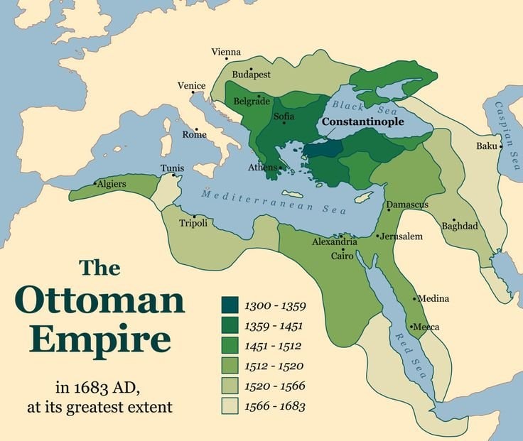
The image is a map showing the Ottoman Empire at its greatest extent in 1683 AD. Different shades of green represent territorial expansion over time, with a legend indicating the periods. Major cities like Constantinople, Vienna, Rome, and Cairo are labeled. The map has a historical and educational aesthetic.
 Virginia district closes 29 schools
 global university enrollment by gender
 2South Korea flight ban exam
 How chromosomes shape baby development
 Harvard study on school cellphone bans
 Richard Feynman on education vs intelligence
 Terence Tao on mathematics
 US climate zones by location
 how to say 92 in European Countries
 Math puzzle challenge
 historical regions of Europe map
 datafut at Casper Líbero
 2Chicago Public Schools vs Google AI
@scarlett_sA long read on the Ottoman Empire as it stood in 1683
ดูโพสต์ต้นฉบับรูปภาพโดย @scarlett_s· Sep 22, 2026· Education
The image is a map showing the Ottoman Empire at its greatest extent in 1683 AD. Different shades of green represent territorial expansion over time, with a legend indicating the periods. Major cities like Constantinople, Vienna, Rome, and Cairo are labeled. The map has a historical and educational aesthetic.
ยังไม่มีความคิดเห็น มาเป็นคนแรกกันเถอะ!
Virginia district closes 29 schoolsglobal university enrollment by gender2South Korea flight ban examHow chromosomes shape baby developmentHarvard study on school cellphone bansRichard Feynman on education vs intelligenceTerence Tao on mathematicsUS climate zones by locationhow to say 92 in European CountriesMath puzzle challengehistorical regions of Europe mapdatafut at Casper Líbero2Chicago Public Schools vs Google AI
ยังไม่มีความคิดเห็น มาเป็นคนแรกกันเถอะ!