
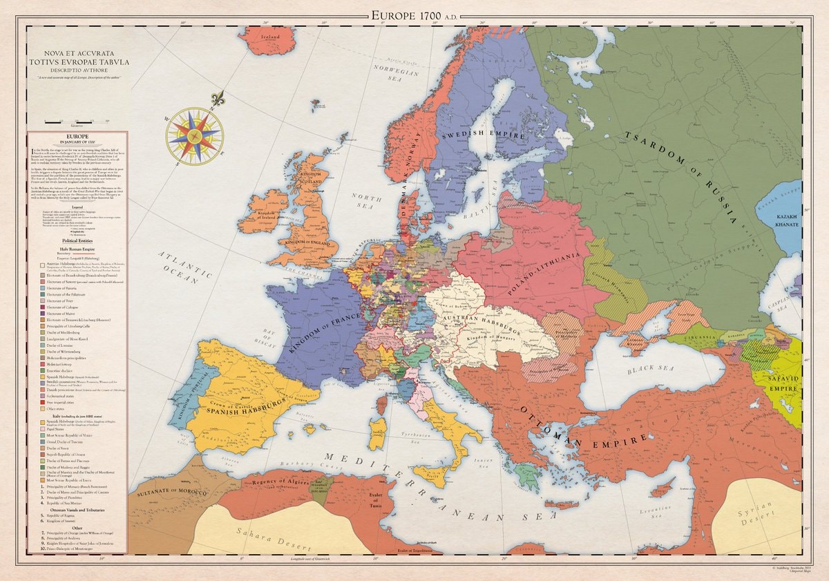
@scarlett_sA whole different map back then, Europe was something else in 1700
ดูโพสต์ต้นฉบับ@scarlett_sA whole different map back then, Europe was something else in 1700
ดูโพสต์ต้นฉบับรูปภาพโดย @scarlett_s· Aug 30, 2026· News
The image is a historical map of Europe in 1700 AD. It displays political boundaries and territories with various colors representing different empires and kingdoms. The map has a vintage aesthetic with a compass rose and a detailed legend. A notable detail is the extensive coloring of the Holy Roman Empire into many smaller states. ON-SCREEN TEXT: EUROPE 1700 A.D. NOVA ET ACCVRATA TOTIVS EVROPAE TABVLA DESCRIPTIO AVTHORE "A new and accurate map of all Europe. Description of the author." Legend Political Entities Holy Roman Empire Boundary Additional (Habsburgs, Electors, etc.) Electorate of Bavaria Electorate of Cologne Electorate of Mainz Electorate of Trier Electorate of Saxony Electorate of Brandenburg Electorate of the Palatinate Duchy of Bavaria Duchy of Saxe-Lauenburg (Saxony) Duchy of Saxe-Gotha Duchy of Saxe-Meiningen Duchy of Saxe-Weimar Principality of Ansbach Princip
 2Tom Holland highest grossing actor
 Roblox top creators earnings
 Gulf Oil Routes Compromised Map
 2BRICS Summit India vegetarian menu controversy
 Donald Tusk warning on Russian escalation
 2Trump on Flock cameras
 2Charlie Kirk statue vandalism
 2Switzerland switches to open-source
 Akku Yadav Nagpur India
 2Mamdani sued by National Supermarket Association LOCAL 38 UFCW
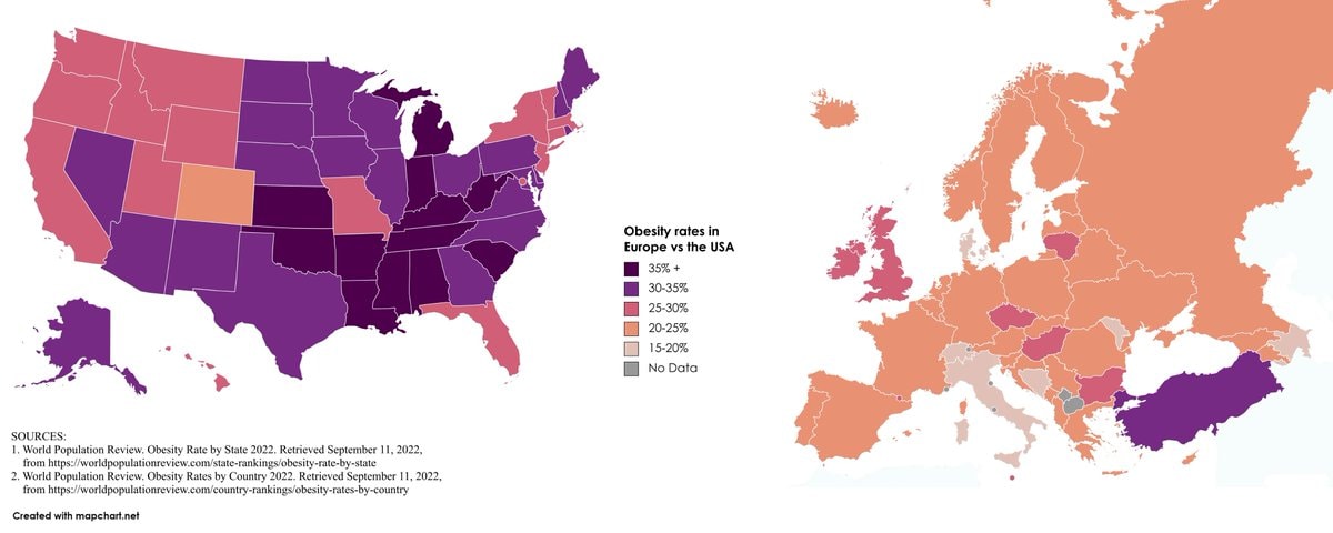 Europe vs USA obesity rates
 2Grand Theft Auto VI Miami Beach ad approval
 2United Airlines CEO Scott Kirby
 2PlayStation protest for physical games
 Bloodhound Q50
 I'm single and searching 😔
@scarlett_sA whole different map back then, Europe was something else in 1700
ดูโพสต์ต้นฉบับรูปภาพโดย @scarlett_s· Aug 30, 2026· News
The image is a historical map of Europe in 1700 AD. It displays political boundaries and territories with various colors representing different empires and kingdoms. The map has a vintage aesthetic with a compass rose and a detailed legend. A notable detail is the extensive coloring of the Holy Roman Empire into many smaller states. ON-SCREEN TEXT: EUROPE 1700 A.D. NOVA ET ACCVRATA TOTIVS EVROPAE TABVLA DESCRIPTIO AVTHORE "A new and accurate map of all Europe. Description of the author." Legend Political Entities Holy Roman Empire Boundary Additional (Habsburgs, Electors, etc.) Electorate of Bavaria Electorate of Cologne Electorate of Mainz Electorate of Trier Electorate of Saxony Electorate of Brandenburg Electorate of the Palatinate Duchy of Bavaria Duchy of Saxe-Lauenburg (Saxony) Duchy of Saxe-Gotha Duchy of Saxe-Meiningen Duchy of Saxe-Weimar Principality of Ansbach Princip
2Tom Holland highest grossing actorRoblox top creators earningsGulf Oil Routes Compromised Map2BRICS Summit India vegetarian menu controversyDonald Tusk warning on Russian escalation2Trump on Flock cameras2Charlie Kirk statue vandalism2Switzerland switches to open-sourceAkku Yadav Nagpur India2Mamdani sued by National Supermarket Association LOCAL 38 UFCWEurope vs USA obesity rates2Grand Theft Auto VI Miami Beach ad approval2United Airlines CEO Scott Kirby2PlayStation protest for physical gamesBloodhound Q50I'm single and searching 😔