iFANN
    ค้นหาใน iFANN...
    เข้าสู่ระบบ
    หน้าแรก
    ข่าว
    วิดีโอ
    รูปภาพ
    GIF
    สำรวจ
    โพล
    รางวัล
    iFAMOUS
    วิกิ
    อนิเมะ
    ห้อง
    การแจ้งเตือน
    ข้อความ
    ที่บันทึกไว้
    โปรไฟล์
    วิกิรางวัลiFAMOUSอันดับอุตสาหกรรมรางวัลครีเอเตอร์รางวัลผู้ใช้ข้อกำหนดความเป็นส่วนตัวหลักเกณฑ์ชุมชนแจ้งลบ / DMCAช่วยเหลือนักพัฒนา

    © 2026 iFANN

    หน้าแรก
    ค้นหา
    ข้อความ
    การแจ้งเตือน
    โปรไฟล์
    รูปภาพ
    Scarlett S
    Scarlett S@scarlett_s1mo
    💭News💭Info/Editorials
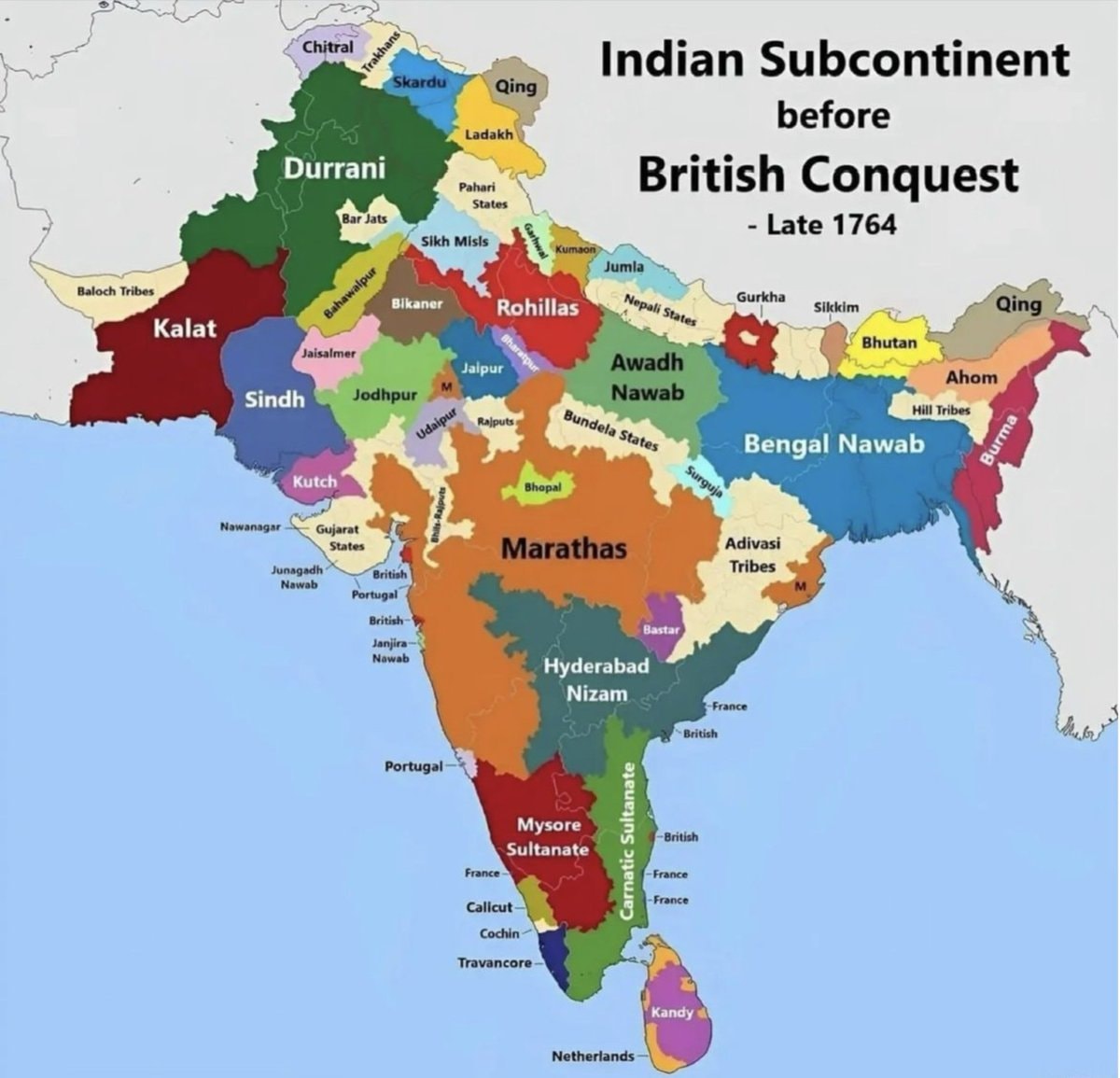
    India map late 1764 before British conquest

    @scarlett_sA map of india from late 1764, before the british conquest. it shows territories like durrani, kalat, sindh, kutch, marathas, hyderabad nizam, mysore sultanate, bengal nawab, and awadh nawab. european colonial areas like british, portuguese, french, and netherlands are also marked

    ดูโพสต์ต้นฉบับ

    India map late 1764 before British conquest

    รูปภาพโดย @scarlett_s· Jul 26, 2026· News

    เกี่ยวกับรูปนี้

    The image is a historical map of the Indian subcontinent. It shows various regions and kingdoms before the British conquest, specifically labeled as "Late 1764." The map uses different colors to delineate territories such as Durrani, Kalat, Sindh, Kutch, Marathas, Hyderabad Nizam, Mysore Sultanate, Bengal Nawab, and Awadh Nawab. The style is informational and educational, with clear labels for each region and some smaller territories. A notable detail is the presence of European colonial territories like British, Portuguese, French, and Netherlands marked on the map. The title "Indian Subcontinent before British Conquest - Late 1764" is prominently displayed at the top right.

    ดูรูปภาพ News ทั้งหมด

    ?

    ยังไม่มีความคิดเห็น มาเป็นคนแรกกันเถอะ!

    รูปภาพ News เพิ่มเติม

    ดูรูปภาพ News ทั้งหมด
    Tisha Campbell MartinTisha Campbell MartinMamdani NYC free restroom 10 minute limit2Mamdani NYC free restroom 10 minute limitLuke Rudkowski questions Jeff Bezos at jury dutyLuke Rudkowski questions Jeff Bezos at jury dutyMerriam-Webster dictionary update2Merriam-Webster dictionary updateStrait of Hormuz emissions drop2Strait of Hormuz emissions dropNYC public toilet time limitNYC public toilet time limitNATO naval officer uniform2NATO naval officer uniformYFG Fatso affiliates shot at near 79th & MarylandYFG Fatso affiliates shot at near 79th & MarylandTehran billboard advertises Janfada missile trainingTehran billboard advertises Janfada missile trainingBattle for the Kahbub mountains above Bab el-Mandeb3Battle for the Kahbub mountains above Bab el-MandebJoe Rogan on Trump supporters2Joe Rogan on Trump supportersMajor companies based in SpainMajor companies based in SpainNia Long Hollywood Walk of Fame starNia Long Hollywood Walk of Fame starDuda Alves TikToker dies at 22Duda Alves TikToker dies at 22germany sixteen statesgermany sixteen statesMinnesota shoplifter resembles Jennifer LopezMinnesota shoplifter resembles Jennifer Lopez2026 Atlantic hurricane season forecast2026 Atlantic hurricane season forecastExxon Venezuela PDVSA oil dealExxon Venezuela PDVSA oil deal
    รูปภาพ
    Scarlett S
    Scarlett S@scarlett_s1mo
    💭News💭Info/Editorials
    India map late 1764 before British conquest

    @scarlett_sA map of india from late 1764, before the british conquest. it shows territories like durrani, kalat, sindh, kutch, marathas, hyderabad nizam, mysore sultanate, bengal nawab, and awadh nawab. european colonial areas like british, portuguese, french, and netherlands are also marked

    ดูโพสต์ต้นฉบับ

    India map late 1764 before British conquest

    รูปภาพโดย @scarlett_s· Jul 26, 2026· News

    เกี่ยวกับรูปนี้

    The image is a historical map of the Indian subcontinent. It shows various regions and kingdoms before the British conquest, specifically labeled as "Late 1764." The map uses different colors to delineate territories such as Durrani, Kalat, Sindh, Kutch, Marathas, Hyderabad Nizam, Mysore Sultanate, Bengal Nawab, and Awadh Nawab. The style is informational and educational, with clear labels for each region and some smaller territories. A notable detail is the presence of European colonial territories like British, Portuguese, French, and Netherlands marked on the map. The title "Indian Subcontinent before British Conquest - Late 1764" is prominently displayed at the top right.

    ดูรูปภาพ News ทั้งหมด

    ?

    ยังไม่มีความคิดเห็น มาเป็นคนแรกกันเถอะ!

    รูปภาพ News เพิ่มเติม

    ดูรูปภาพ News ทั้งหมด
    Tisha Campbell MartinTisha Campbell MartinMamdani NYC free restroom 10 minute limit2Mamdani NYC free restroom 10 minute limitLuke Rudkowski questions Jeff Bezos at jury dutyLuke Rudkowski questions Jeff Bezos at jury dutyMerriam-Webster dictionary update2Merriam-Webster dictionary updateStrait of Hormuz emissions drop2Strait of Hormuz emissions dropNYC public toilet time limitNYC public toilet time limitNATO naval officer uniform2NATO naval officer uniformYFG Fatso affiliates shot at near 79th & MarylandYFG Fatso affiliates shot at near 79th & MarylandTehran billboard advertises Janfada missile trainingTehran billboard advertises Janfada missile trainingBattle for the Kahbub mountains above Bab el-Mandeb3Battle for the Kahbub mountains above Bab el-MandebJoe Rogan on Trump supporters2Joe Rogan on Trump supportersMajor companies based in SpainMajor companies based in SpainNia Long Hollywood Walk of Fame starNia Long Hollywood Walk of Fame starDuda Alves TikToker dies at 22Duda Alves TikToker dies at 22germany sixteen statesgermany sixteen statesMinnesota shoplifter resembles Jennifer LopezMinnesota shoplifter resembles Jennifer Lopez2026 Atlantic hurricane season forecast2026 Atlantic hurricane season forecastExxon Venezuela PDVSA oil dealExxon Venezuela PDVSA oil deal